To See original Review, Visit http://www.boatadvice.com.au/simrad-3d-structurescan-review/
The introduction of new technology in fishfinders has been moving at a whirlwind pace in recent years making it hard to keep up, or in touch with, the latest developments. And this year the technology “war” between the big four players in the industry was taken to another level with Navico the first to introduce 3D StuctureScan technology for its Simrad and Lowrance brands. It is technology that will make it easier to find fish and identify structure than it has ever been. It will also be easier to use and read, which means for most of us we may be able to get close to fully understanding what we are actually looking at on the screen.
Two dimensional side scan has been on the market for years and while it certainly increased the amount of ground we could cover and the way we looked for fish and structures, much of its success depended on how well you understood and read your sounder.
What 3D has done has taken the guess work out. You can now clearly see the structure and its size. We had a Simrad 3D StructureScan fitted to a 9-inch NSS evo2 and took it out to a favourite fishing spot for a look.
WHAT YOU GET
As we pointed out earlier the 3D Structure scan is an additional transducer that you connect to your existing fishfinder (provided it’s capable of displaying 3D Structure Scan), in this case a Simrad NSS evo2. The secondary transducer is normally fitted on the opposite side of the transom to your primary transducer but can be fitted alongside, as long as they are far enough apart not to interfere which each other, if necessary.
The transducer is then connected to a module fixed somewhere in the cabin or under the dash that in turn is connected to your NSS unit.
Apart from the unrivaled side scan image clarity the 3D scanner also comes with:

 Leading Edge —
a scanning reference that provides a clear graphical illustration of the sonar beams as they intersect with the bottom contours to provide and a better sense of target depth.
 SelectScan –
which is target colouring that automatically shades fish-holding cover and suspended targets in a contrasting colour to make them easier to identify.
 Vertical Depth Enhancement –
which emphasises vertical drops and crucial depth contour changes making them easier to identify relative to the surrounding terrain.
 3D Waypoint Overlay –
which allows you to revisit fishing areas, structure and other underwater spots of interest. You can use the waypoint keypad to save a waypoint at the boat location or switch to cursor mode and save a waypoint over specific targets, baitfish schools or cover.
HOW DOES IT WORK –
In really simple terms the 3D scanner operates the same as shooting a 3D movie. To create a 3D film you focus two lenses on the same object to give it multiple dimensions. In the world of fishfinders the sonar signal that is sent out by the transducer is received by two separate elements on its return which provides a multi-dimensional image. The image below shows 2D on the top half and 3D of the same ground on the bottom.
ON THE WATER
To get a good understanding of the 3D scanner we headed to an area off Hillarys in the northern suburbs of Perth that is a popular spot for fishing and diving due to the big area of reef with plenty of structure and swim throughs that attract a vast variety of fish as well as the highly sought-after crayfish.
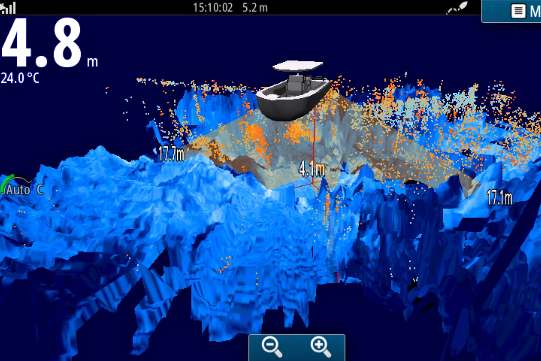
Once we arrived at our destination we turned off the engine of the boat and allowed the gentle sea breeze to blow us across the water. The 3D scanner works best at speeds between 2-8km/h (1-4 knots) so drifting provided a really clear image of the terrain and allowed us to spend plenty of time “playing” with the 3D scanner. While nobody on the boat was fully clued in with the new technology it did not take long to get a handle on it. Not only were we getting a never-before-experienced view of the bottom but we could also change the angle of the view by simply moving a finger across the screen. If you can operate a tablet or phone you will be very comfortable using this.
Shifting our view enabled us to take a closer look at any structure, or schools of fish, that may have caught our attention. It also enables you to shift your viewing to the left or right of the boat, which is really handy when cruising down the side of a ledge. On the screen the fish showed as red dots, a feature of SelectScan that automatically shades fish in a colour that contrasts to the rest of the colour palette. Anything we thought worthy of a closer look was marked as waypoint, a very simple process, so we could drive to the exact spot.
The 3D scanner will work in water up to 90m deep and can shoot sideways up to 180m away from the boat. While this makes covering a big area a lot easier and quicker it also makes it important to ensure you do mark anything that grabs your attention, as it may be further away from the boat than you thought and a little hard to find again without some guidance.
OVERVIEW
The Simrad 3D StructureScan provided a picture of the ocean bottom I have never seen before. And while I like to call my self a keen fisherman I am not a person who has previously taken the time to learn the intricacies of how my sounder works. But after spending about 30 minutes playing with the 3D StructureScan I was not only getting a clear picture of the structure and fish below but was able to manipulate the screen to explore areas up to 100m either side of the boat.
To See original Review, Visit http://www.boatadvice.com.au/simrad-3d-structurescan-review/
